About the Swamp Fox Passage
Region

Difficulty

Length
Activities


Halfway Creek Trailhead – The parking area off of Halfway Creek road was originally designed as a trailhead and does not have the infrastructure to support a trail camp. Therefore, it is no longer considered a designated camping area. The Forest Service has recently ordered new signage to install indicating that it is a trailhead and are working on updating the kiosk.
Also, there is no water available at Witherbee TH and Halfway Creek TH
Due to unforeseen circumstances, the Cane Gully campsite is CLOSED until further notice. We are currently trying to relocate the campsite to another area and will list updates as they become available.
At 47 miles, the Swamp Fox Passage is the longest section of the cross-state Palmetto Trail. The passage traverses four distinct ecosystems through Francis Marion National Forest, including swamps made famous as hideouts of Revolutionary War hero Francis Marion. Mature long-leaf pine forests are home to the endangered red-cockaded woodpecker. Grassy savannas with abundant wildlife border Dog Swamp and Turkey Creek, and a cypress pool footbridge offers excellent views of the impressive Wadboo Swamp. Three trailheads provide users with options for one long trek or shorter day trips. Any access point makes for an enjoyable trip and diverse views.
NOTICE: There are only one water source on the Swamp Fox Passage. The Ranger Station off Steed Creek Road that is roughly 1.2 miles west of where Steed Creek Road crosses the trail between mile 13 and 14.
Signs
Interactive Maps Without Wifi
We have partnered with Avenza Maps in order to offer interactive maps that don't require an internet connection. Using the Avenza App, you can download maps onto your mobile device before you hit the trail, so that you locate yourself and be aware of where you are, even in the remotest of places. Offline location helps you stay on track, on the trail, and out of potential danger.
Get the Map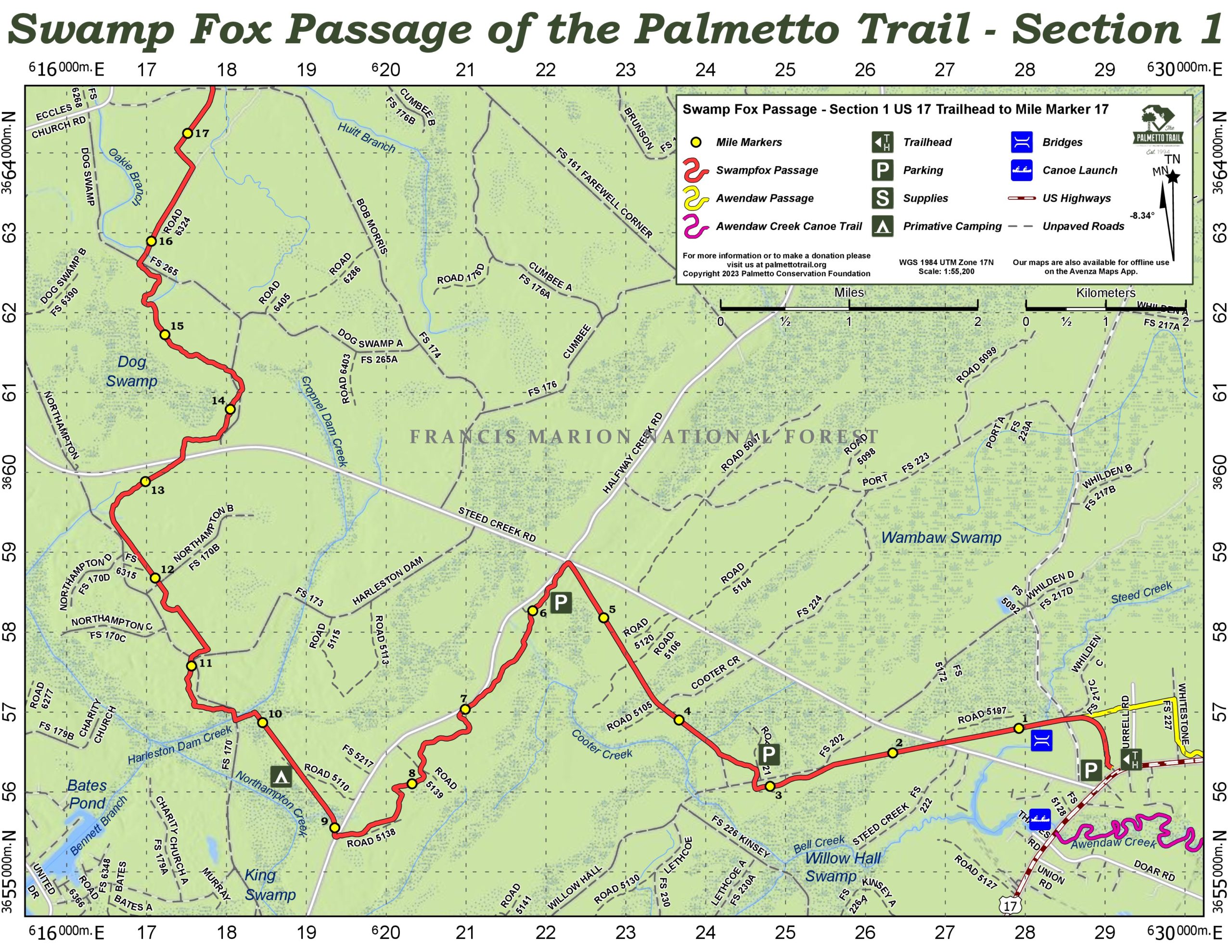
Directions
Steed Creek (eastern) Trailhead—From Charleston, drive north on US Hwy 17 about 27 miles to intersection with Steed Creek Road (S-10-1032) on left side of highway. Trailhead and parking are on left 0.25 mile past Steed Creek Road. To access, drive to next crossover, make a U-turn, and continue back to parking and trailhead, now on right.
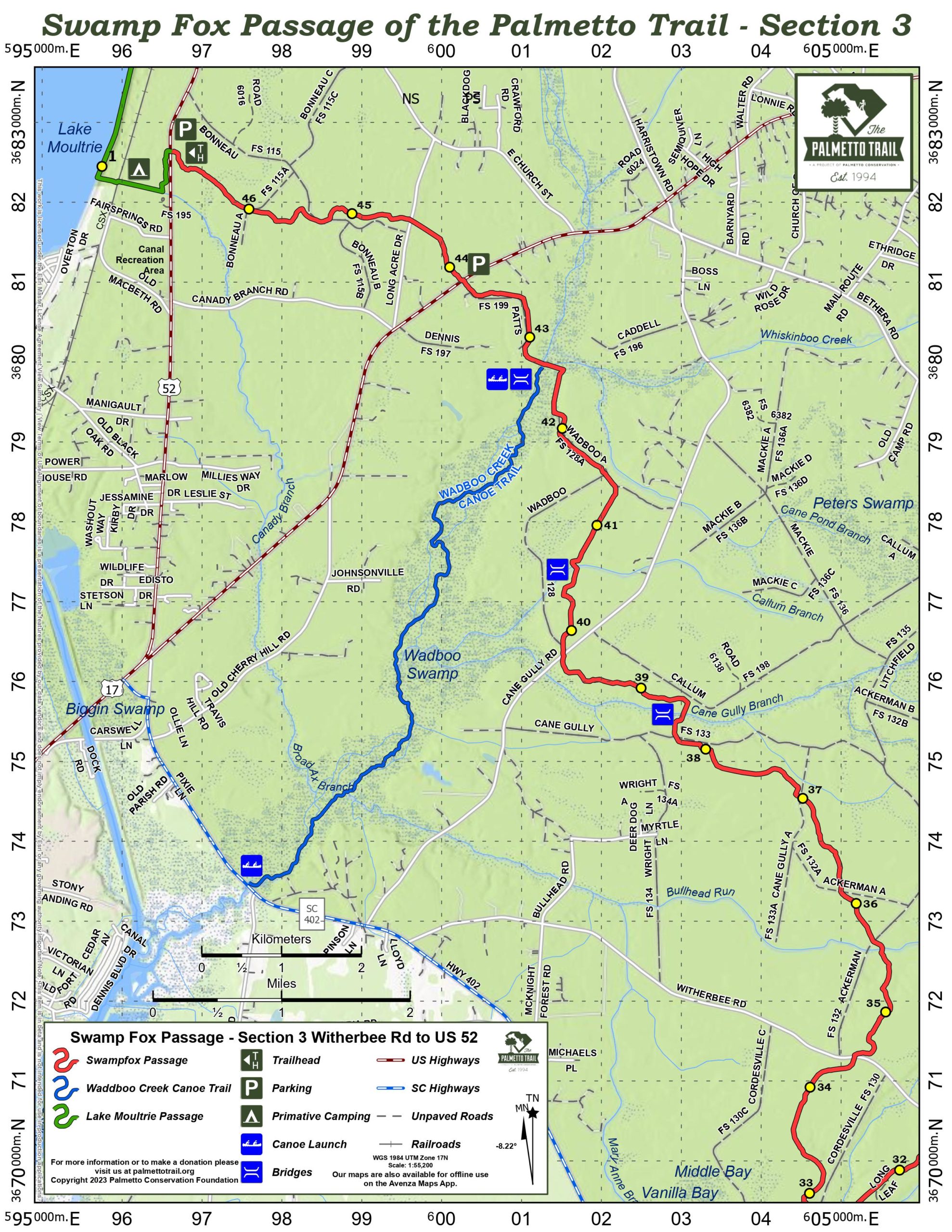
Witherbee Ranger Station (middle) Trailhead—From Charleston, drive north on US Hwy 17 about 9 miles to SC 41. Turn left onto SC 41 and drive 17 miles. At Huger, bear left onto SC 402 and drive 3 miles. Turn right onto Copperhead Road (S-8-125) and drive 2 miles. Turn right onto Witherbee Road (S-8-171) and drive 0.5 mile to parking at Ranger Station on right. The Witherbee Ranger Station is currently CLOSED.
Witherbee Ranger Station (middle) Trailhead—From Moncks Corner, take US Hwy 52 north to SC 402. Turn right and drive 3 miles to Witherbee Road (S-8-171). Turn left and drive 7 miles on Witherbee/Wright Road to parking at the Ranger Station on the right.
US Hwy 52 (western) Trailhead—From Moncks Corner, take US Hwy 52 north. Stay on US 52 about 3.8 miles past the split with US Hwy 17 Alt. Watch for the neon yellow hiker highway sign. The trailhead and parking are on the right.
Halfway Creek Camp Site—From Charleston, drive north on US Hwy 17 about 27 miles to Steed Creek Road (S-10-133). Turn left and drive 5 miles to Halfway Creek Road (S-10-98). Turn left and drive 0.5 mile to campground on left.
Camping
Camping is limited to designated areas. Primitive car camping is available at Halfway Creek, and several backcountry campsites are spaced along the Trail. Cutting live trees for firewood is prohibited.
3 night maximum for camping.
Notes
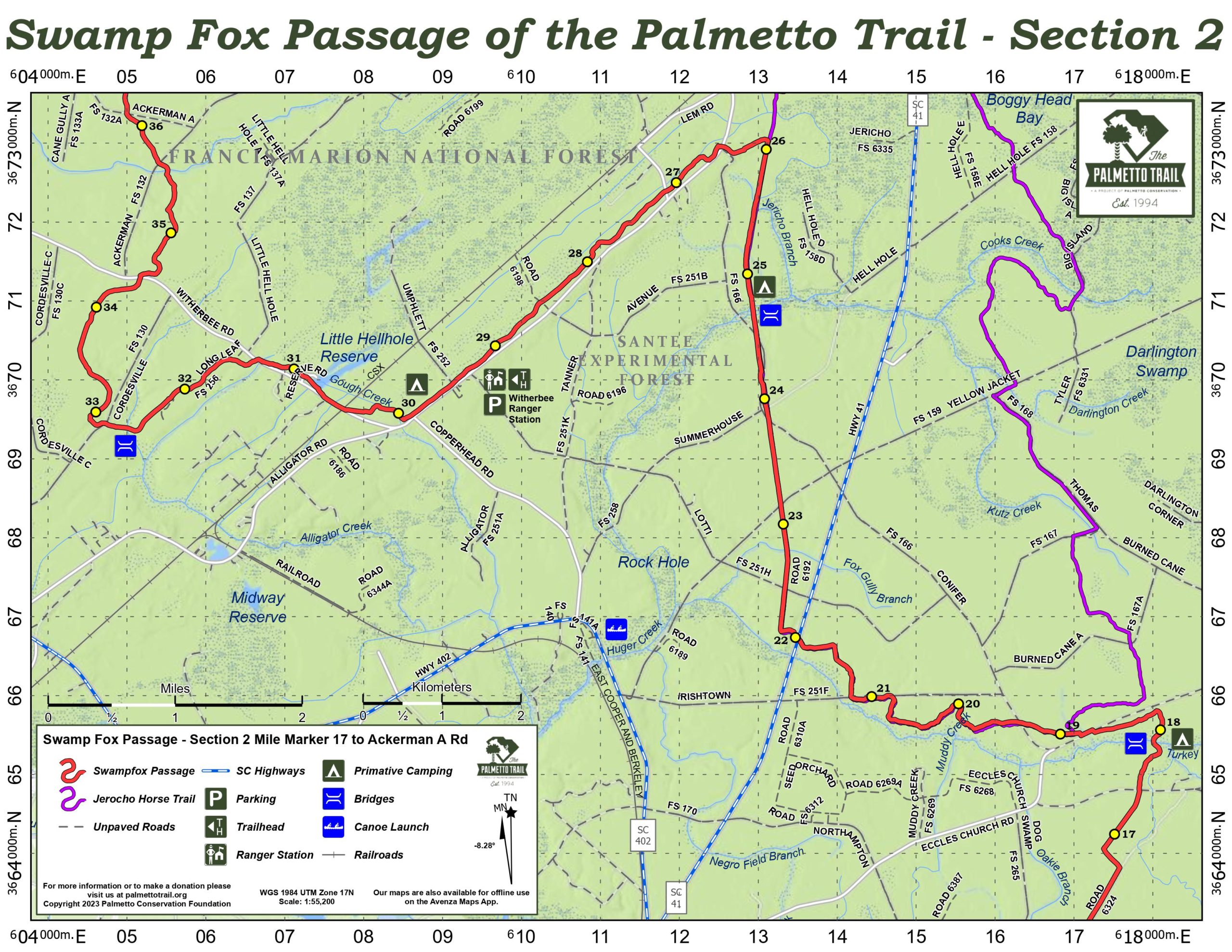
- After Turkey Creek, the Swamp Fox Passage shares the Jericho Horse Trail, from mile marker 19 to 26 (map sections 2 and 3).
- The water source at Halfway Creek campsite, as shown on map section 1, has been removed.
- No water is available at the Witherbee Ranger Station trailhead, as shown on map section 3.
- No restrooms or water are available at the US Hwy 52 trailhead. The former Canal Recreation Area has been closed and decommissioned.
Additional Information
USDA Forest Service, Francis Marion Ranger District, 2967 Steed Creek Rd, Huger, SC 29450, ph (843) 336-2200
Sewee Visitor & Environmental Education Center, 5821 Hwy 17 N, Awendaw, SC 29429, ph (843) 928-3368
Swamp Fox Passage Share Owners
Boy Scout Pack 9212
Cub Scout Pack 707
Hal S. Currey
Rob Dozier
Travis Garriott
Bob & Jane Goble
Christopher Gunther
Al Haynes
James Hodgson
Hayden S. Jacobs
Benjamin Justice
Daniel Justice
Thomas Lahey
Mr. & Mrs. J.H. McCombs
Douglas McElveen
Mr. & Mrs. Jerry Norvell
Sidney and Ben Rex
Steve Rountree
Ashley T. Salmon
Emily & Tyler Smith
Rebecca & Wesley Smith
Mr. & Mrs. Evans Townsend
Logan Wells
Mr. & Mrs. Allison Wilder
Mr. & Mrs. John Wilder
Mr. & Mrs. Leland Wilder
South Carolina Society Children of the American Revolution
Southern Lumber & Millwork Corp
Guy C. Lee Building Materials